


1. Introduction
1.0 Background information
The majority of the air in the atmosphere consists of two gases that are required for life on planet Earth: nitrogen and oxygen. However, many additional gases and particles are present in lesser quantities in the air. Some of these gases in the air have negative effects on the health of both human beings, animals and the environment at large. Hence significant quantities of these are hazardous and may pollute the air making it unclean.
The term “air quality” refers to how clean or dirty the air is. Air quality must be monitored since dirty air is hazardous to human health and the environment. The Air Quality Index is used to assess air quality (AQI). The AQI monitors the following main air pollutants: ground-level ozone, carbon monoxide, sulfur dioxide, and nitrogen dioxide (How Is Air Quality Measured? | NOAA SciJinks – All About Weather, n.d.).
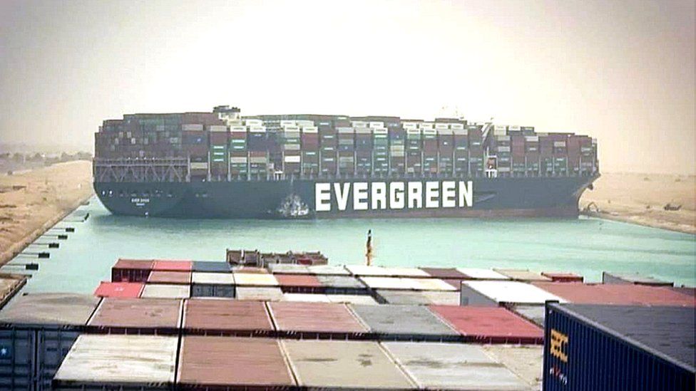
A huge container ship, comparable to a 20,000 twenty-ton cargo ship, got jammed across Egypt’s Suez Canal on March 23, 2021, disrupting one of the world’s major commerce routes. Hundreds of ships were stranded while waiting for rescue boats to arrive to release the 1,312ft vessel that had been blown by high winds. The government and social media were more concerned with the billions of dollars of freight that were blocked every day by this incident. It is moreover expected that the ship could have led to a spike of Sulphur dioxide, Nitrogen oxides and Aerosol Optimal Depth which are used to compute the particulate matter (PM) emissions hence adding pollutants to the air. The ship itself did not emit enough Sulphur dioxide to be of significance, since it was moving around the canal, however, the fact that there was a huge count of ships stuck in the place since they were blocked is the main reason that Sulphur dioxide emissions could have spiked (Suez Canal Blockage Caused a Spike in Air Pollution | Daily Mail Online, n.d.). This research aims at using scientific evidence and empirical studies in investigating the effect of this incident to air quality in the Suez.
1.1 Problem description
The evergreen vessel incident left a blockage of very many ships in the area for the period it was stuck. This is as a result of the Suez Canal being one of the busiest canals for ships navigation and transactions, leaving hundreds of ships stranded while waiting for rescue boats to arrive. During this time, not only business, navigation and the economy was affected but also the air quality. The presence of large number of ships in the area, although with engine off, but with power generators and on-board boilers still in use, led to a spike in the air quality variables. This research aims at using analogous scientific methods to determine the alteration in air quality in the area in that specific period.
1.2 Objectives
1.2.1 General Objectives
To assess the effect on air quality variables caused by the Evergreen Vessel incident in the Suez Canal.
1.2.2 Specific Objectives
- To determine changes in the air quality variables caused by the Evergreen vessel incident.
- To calculate the pollutants present in atmosphere such as particular matter 2.5, carbon monoxide, sulfur dioxide, nitrogen dioxide and particle pollution.
- To investigate the impacts of the ships and vessels emission on air quality index.
1.3 Scope
The research is specific for the area in the Suez Canal only which covers a grid of about 500 km2 in size. The study aims at using model driven approach for the three epochs, that is, the three months of February, March and April, for deriving emission levels for the pollutants. The use of ground monitoring stations is greatly limited by the absence of air quality station within the grid, the closer one being at New Cairo city. Satellite data from NASA Earth data on air quality is also used for comparison and validation.
2. Scoping Literature Review
2.1 Components and standards for Air Quality Indices
Air Quality Index (AQI) is a scaled approach developed by the United States Environmental Protection Agency to report on the five pollutants: Ozone, Particulate Matter (PM 2.5 and PM 10), CO, SO2, and NO2 (Ragazzi, 2017). The index ranges from 0 to 500 such that values greater than 101 indicate and risk for the public health. The use of colors can be helpful in visually representing the values through use of maps. Air quality can also be calculated for a single pollutant as mentioned above, if it’s the pollutant of interest. For example in this study, NO2, SO2, CO and Particulate Matter are of interest (Godish, 2003).
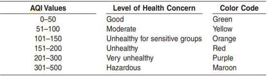
Figure 1 Air quality index values
2.2 Effects of shipping on Air Quality
Marine ports such as the Suez Canal use different modes of transport, running on diesel power engines burning fossil fuels. A study carried out by the U.S EPA in 2002 indicates that marine vessels contribute to 70% of air pollution in ports. Handling trucks and cargo handling is also done using heavy machinery using diesel engines. The nature of ports and the transport modes make them vulnerable to getting more air pollutants (Viana et al., 2014).
The Suez Canal is a major economic block in world trade as it provides shorter routes from Europe to Asia and Africa to Europe. The amount of cargo therefore keeps in increasing yearly. Albeit, in effect of the Corona Virus and lock down restrictions in several countries, the use of small vessels such as yachts have reduced, the same is not applicable for container vessels (Duncan et al., 2014).
2.3 Use of Mathematical Models for Emission Calculations
Using the inventory of containers in the canal, the emission from ships can be calculated using energy-based emission factors and the activities profile for each vessel (Moustafa & El, 2007). The heavy lifting using thus methodology brought forth by the U.S EPA is determining the engine power and using the formulae below:
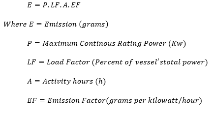
There are multiple factors to be computed in order to derive the emission (E). The elements include characteristics of the vessels that is needed for calculating the ship movements, the vessel model (Moustafa & El, 2007). The load factor is determined by:
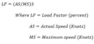
The challenging part in the models is determining the engine emission factor, given the ships were most likely stationery during the blockage of the Evergreen Vessel. Meaning that Sulphur was less burnt during this period.
2.4 Time Series Analysis of Emissions
The data obtained from the mathematical models have to be analyzed according to their time of occurrence. This brings in the factor of time series analysis and exploratory data analysis tools. The time epochs for the emissions is 3 months denoting the period before the incident, during the incident and after the incident. A trend analysis has to be carried out for each type of vessel and for the type of pollutants being investigated. Tools such as Pandas and Stats models libraries would come in handy for the data analysis.
2.5 Derivation of Pollutant Emissions from Remote Sensing Imagery
The availability of earth observation satellites has made it possible for organizations such as NASA and NOAA to be able to leverage this technology for measuring atmospheric composition for air quality applications (Salvador & Salvador, 2012). Satellite data has proven to be advantageous due to the spatial coverage. Satellite data can be used for qualitative analysis via visualization and quantitative estimation of pollutants which involve use of empirical models. Satellites are able to air molecules within the vertical column density to determine emissions such as NO x, methane, Aerosol Optimal Depth (AOD) (Duncan et al., 2014). The ability of satellites to have a large spatial coverage makes it possible to use the data for validation of the mathematical models. Remote sensing data also proves useful for deriving surface estimates of short lived pollutants such as SO2 and NO2 (Duncan et al., 2014) .
An important issue when dealing with remote sensing data is the resolution, both spatial and temporal. The data ought to be within the same time frame and more importantly the ground resolution for the data should be the same. An example with this study is the use of MODIS Terra and Aqua dataset having a spatial resolution of 1Km and Aura Ozone Measuring Instrument having 7Km resolution. The data has to be rescaled to the larger resolution for the 500 Km2 grid.
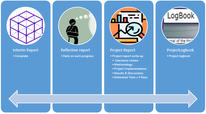
3. Project Management & Progress
The project has been dissected into four procedures including the interim report, project report, reflective report and project logbook.
4. Closing statements
The assessment of air quality in ports is particularly an interesting topic of study, what makes this specific research interesting is the combination of remote sensing imagery and mathematical models for air quality in the Suez Canal. Hopefully, the research could also be backed by ground stations observations, but the combination of the two could prove useful for determining the pollutants affected most by the Evergreen vessel incident in March 23rd 2021.