


- Arbor Low
Arbor Low is a Neolithic stone hedge located in the Derbyshire Peak District. It is one of the many barrows located in the region. Another site, the Gib Hill, is located about 300 meters south-west of the Arbor Low. The Arbor Low has about 50 stones which form a circular shape. It is likely that the stones may have been as a result of human action about 25 to 15 centuries ago (Bailey, S., 2019). The site is a collection of stones that are fallen and ruined. It is likely that the initial number of stones may have been less and the degradation activities that have been taking place over the years may have caused the split of some, hence raising their count. The stones lie on the ground. Their positions, however, seem to be as a result of activities that may have taken place over the years. It is likely that they were, in their initial days, upright in posture with reference to their purpose. The hedge is one of the most important prehistoric sites in England. The site is well accessible through a road that runs about 500 meters away from the site. The fieldwork activities done at the Arbor Low involved a walkover survey to explore the open site. The prehistoric site is open for access during daytime hours. The climate of the region is favorable for exploration since the site is located in a high moorland. During the fieldwork, an observation was the main method of data collection. Taking notes was the most favorable way of storing the observed information. From the observation, it was evident that the stone hedge is of significant importance to archaeologists.
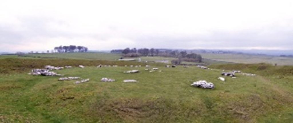
Photo 1: Arbor Low (Collyer, 2019)
The circular formation of the stones is tangible evidence of human settlement. The main pieces of evidence are that the stones are in a circular arrangement and the stones have a close range of length. The evidence point to human action. It is unlikely that existence is natural. From the archaeological shreds of evidence, the site adds significantly to the knowledge of the region. They denote that human beings have been in the region for more than 10 centuries. The Neolithic age in which they were formed was characterized by organized human living. It is likely that people who lived there during the period of its formation had a formal system of living in which there was social stratification. The arrangement of the stones may mean that the central position was reserved for the royal persons while the circular formation was for their servants or commoners. There is also a possibility that the site was a place reserved as a cemetery for the community living in the region. Either way, it is an indication that it was a settlement for people, and that the people believed in burial as opposed to other ways of discarding dead bodies. The evidence of the position in which the stones lay is an indication that the stones have existed for long. It is likely that the stones lived through the ages that followed. They were, therefore, affected by the activities of the newer ages. An example of such is the change in beliefs. People who did not believe in the burial system may have contributed to ruining the site by destroying the stones. This factor does not, however, rule out the possibility of other factors such as natural occurrences.
- Eyam
Eyam is a historic village. It is located in the Peak National Park in Derbyshire, England. It is a multi-period historic site. The village became famous after the Great Plague of 1665 and 1666, also known as the Black Death (Holloway, 2017). It is one of the most famous historic sites in the region owing to its rich history. It rose as a place in which people living within worked towards isolating themselves from the rest of the population in an effort to contain the plague within a specified area. The plague badly affected the village, sweeping a significant majority of the people living in the region. Descendants of those who survived during the plague are still in existence, although others have dispersed over time to other places with the changes in village life. A visit to the historic site is exciting fieldwork. It offers a lot to learn about especially from the changes that have occurred over the years. The village is vibrant with people and businesses are doing well, especially due to the support of tourism. It is also well accessible by road. The weather conditions are favorable enough to allow a walkover survey and the numerous attractions within offer a lot of archaeological sources of information. Archaeologists have a rather easy time studying the village since there already are a lot of pieces of evidence regarding the different periods that the village has been in existence. Among them are the numerous paintings depicting various phenomena.
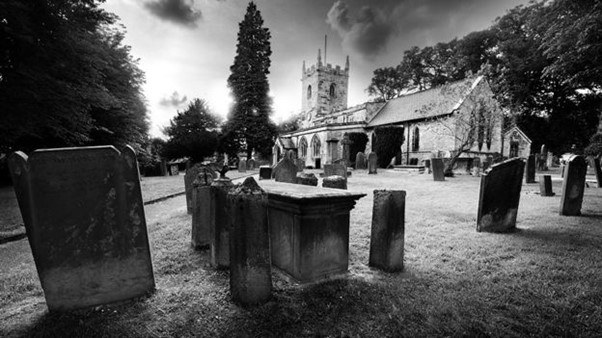
Photo 2: Eyam Village (McKenna, 2016)
The village is ambient with paintings from different eras of art. The paintings depict various things that are of great importance to the village and its community such as victims of the plague and the industries developed by local people in different periods despite the harsh conditions. Another source of archaeological evidence is literature. The village is known for its publication of works of literature such as poems and novels which date back to the 19th century. From their content, archaeologists deduce important information. Music and theatre also add to the sources of valuable information from which archaeology gains information regarding the village and its dynamics. The village also has places of interest, especially those related to the plague. Such include the Coolstone and the Boundary Stone (Holloway, 2017). The archaeological information offers evidence that the village has been experiencing various events in the history of human beings. This information contributes to our understanding of the people living in the region in several ways. One of them is that the people lived in villages in the 19th century. The fact that it was possible to place a group of people in one village and close them in explains that they had a well-defined stratification that enabled them to determine where each group was to stay. The stratification also enabled them to determine the roles of each group of people. The evidence also shows that people of the region relied on industries such as mining lead. The industries formed a significant part of their economy. Over the years, the economic activities have been diversified to such activities as the sale of paints and publishing literature for sale. The event of the plague, being the main reason for the fame of the village, is also of immense importance in studying the people of the village. It explains their moral values in relation to the way they responded to the disease. The paintings, literature, and other features of interest in the village better express the values. They are ways of remembering the fallen as a value of the community.
- Sheffield General Cemetery
The Sheffield General Cemetery is a cemetery located southwest of Sheffield City, England. It is an industrial age historical site. The cemetery was opened in 1836 and the activities of burial were closed in 1978. It is home to more than 87000 persons buried over the period of its operation (Rugg et al., 2014). It has numerous notable buildings that resemble the Egyptian architectural designs. The cemetery is also characterized by notable changes in the beliefs of people in reference to the church. Fieldwork in the cemetery offered a lot of information. Of importance to note is the accessibility of the cemetery especially due to the development of infrastructure in honor of the cemetery’s significance and its proximity to the city center of Sheffield City. The outdoor heritage area can be accessed for exploration. Its elaborate features make it easy to collect information by mere observation. The cemetery area is easy to define since its boundaries are marked by notable features such as the Cemetery Road and a gate. Conducting fieldwork in the place offers an exciting experience since the cemetery offers deep historical information that can be used for archaeological purposes. Taking notes and photographs were used for recording information. Currently, it is managed by a community group. The management of the cemetery is part of its history.
Photo 3: Sheffield Cemetery (Cemetery History, 2019)
The site is characterized by numerous archaeological discoveries. Among them is the non-conformist chapel. The chapel is built using Egyptian architectural designs. It signifies the people who refused to conform to the teachings of the Church of England. It also has a sculpted dove which symbolizes the holy spirit. Another is the Anglican chapel. The chapel defies the common way of architecture and resembles the Neo-Gothic style. Its style is also of significance to archaeologists. A wall, the Dissenter’s Wall, separates the older form of non-conformists from the newer Anglican context. The Egyptian gate and gatehouse are notable from a distance. Although they form the entrance, they also offer important historical information. The gate has sculptures of two coiled snakes whose tails extend into their mouths. Each of the archaeological pieces of evidence has distinct value in our understanding of the surrounding region. First is that the area is inhabited by people of diverse religious and cultural values. The diversity of the architecture and the sculptures that represent different phenomena supports the idea of diversity amongst the people. The evidence in the cemetery also explains that the changes in beliefs over time. The fact that the cemetery is an establishment of the local authority is evidence that the people living within the region have been changing their paths from the traditional ones in which people looked up to the church in such stages of life as burial to a more secular perspective in which people are now looking up to the local authorities for arrangements on the same. It also explains the changes in beliefs and values over time. The use of specific symbols and sculptures at the cemetery also explains the values of the region. An example is the representation of the Holy Spirit using a dove to signify the belief in Christianity. Egyptian architectural designs also play a major role in explaining the lifestyles of people in the region. It signifies that there had been massive interaction between the people of Sheffield and Egyptians which has led to immense cultural exchange. It suggests that there is another area of research in their interaction that needs further research.
- Wincobank Hillfort
Wincobank Hillfort is a fort on the Wincobank Hill that overlooks the Don Valley in Sheffield, England. The monument is oval and covers a space of about 10,000m2. Carbon dating shows that it dates back to the iron age. The area can be accessed at any time whenever the conditions of the weather are favorable. An exploration in the region allows viewers to see various features of the fort. A description of the fort is that it is a formulation on the hill that depicts it as the construction of human beings. It has both the inside and external parts of it. The interior is a formation of the natural hill while it is surrounded by a ditch on the outer area. It is, however, hard to tell the exact place in which the entry was located due to a series of events that have occurred on the fort. The archaeological excavation was done in 1979. Among the archaeological discoveries of the place is a vitrified bank (Wadsworth et al., 2015). It is likely that the bank was vitrified during construction. There is also a possibility that an external invasion may have led to the same. Known history about the region supports the archaeological discoveries. It is likely that the place was used for such purposes as a congregation, social activities, trading, and seeking shelter during times of war. Its architectural design allows for such and other activities. An example of such useful periods is that it is likely to have been used during the Roman invasion to provide refuge for the tribes who lived in the place at the time as they hid from the Roman soldiers. Its purpose is, therefore, of interest to history and a source of information to archaeologists.
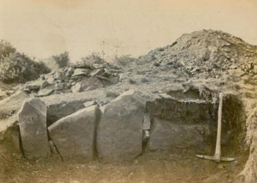
Photo 4: Wincobank Hillfort (Auty, 2019)
The information gained from archaeological discoveries offers valuable information that adds to our understanding of the region. Among the notable concerns is that the region may have been prone to war. The presence of a fortress shows the inhabitant’s efforts in creating a defensive mechanism for themselves. It is likely that the people who lived in the region were facing difficulties in handling people from neighboring places who had better weaponry or other advantages in war. Creating defensive mechanisms such as the fortress was a good way in which the people would shield themselves from the attacks. The vitrified bank adds weight to the information in that it offers evidence of the likelihood of the place having been attacked during the war as people hid from the attacks. Also, the fact that war was a common occurrence during the period supports the idea of the place is a fort. The Roman invasion happened at about the same period to which archaeological evidence dates. These factors support the possibility of the people being subject to constant attacks. From the perspective of the place being a meeting or trading place, it is likely that the inhabitants found the place unique for such social activities. The natural design of the place coupled with their building techniques offered them the luxury of meeting in such a unique place. It means that the people living in the place were good at architecture. It is evident that the region may have been the origin of architectural designers who spread their expertise to other places with Wincobank being the origin of the designs. It, therefore, places Wincobank on the world map as one of the origins of unique architectural designs.